Bagg Family Dispute part 1: Stanley Clark Bagg’s Estate

Written by Janice Hamilton, with research by Justin Bur

Note: there were three generations named Stanley Bagg, so for the sake of brevity I use their initials: SCB for generation two, Stanley Clark Bagg, and RSB for generation three, Robert Stanley Bagg.

Be careful what you wish for, especially when it comes to writing a will and placing conditions on how your descendants are to use their inheritance. That was a lesson my ancestors learned the hard way.

It took a special piece of provincial legislation in 1875 and what appears to have been a family crisis before these issues were finally resolved many years later. 

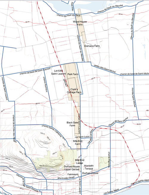
The estate at the heart of these problems was that of the late Stanley Clark Bagg (1820-1873), or SCB. He had owned extensive properties on the Island of Montreal. Several adjacent farms, including Mile End Farm and Clark Cottage Farm, stretched from around Sherbrooke Street, along the west side of Saint Lawrence Street (now Saint-Laurent Boulevard), while three other farms extended along the old country road, north to the Rivière des Prairies. SCB had inherited most of this land from his grandfather John Clark (1767-1827).  Although he trained as a notary, SCB did not practise this profession for long, but made a living renting and selling these and other smaller properties.  

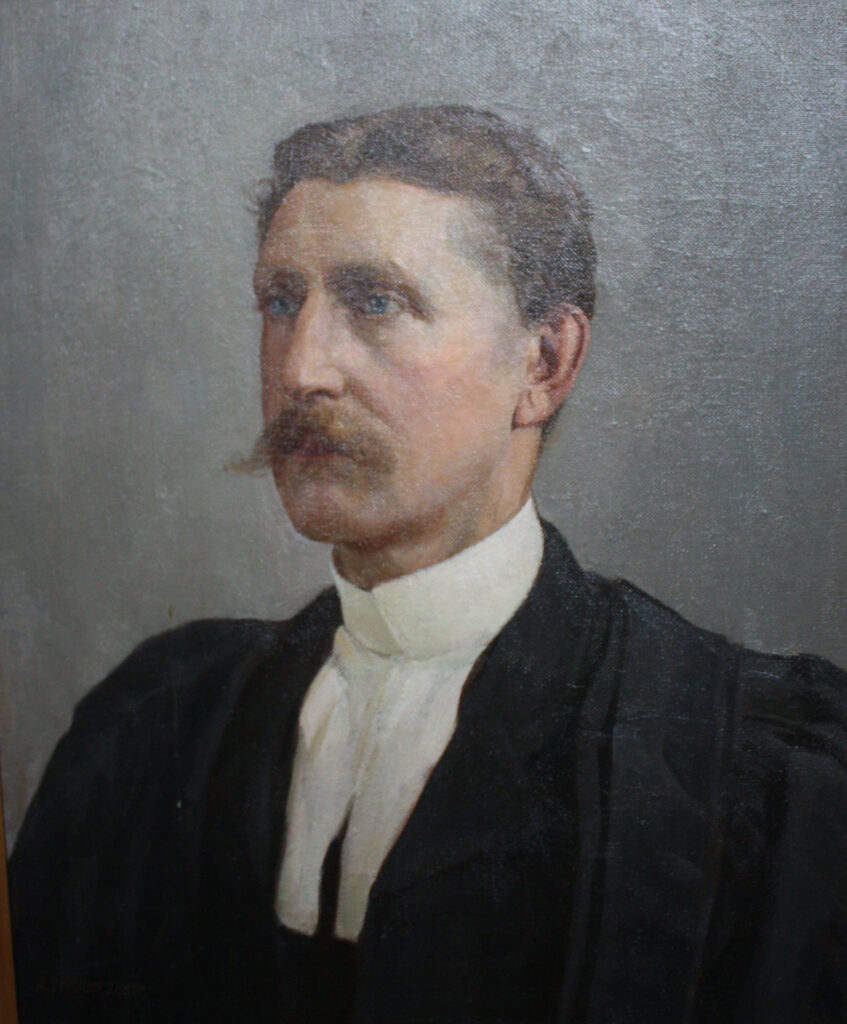
Stanley Clark Bagg, Montreal, QC, William Notman, #1-5660.1, McCord Stewart Museum

At age 52, SCB suddenly died of typhoid. In his will, written in 1866, he named his wife, Catharine Mitcheson Bagg (1822-1914), as the main beneficiary of his estate, to use and enjoy for her lifetime, and then pass it on to their descendants. He also made her an executor, along with his son Robert Stanley Bagg (RSB, 1848-1912). There were two other executors: Montreal notary J.E.O. Labadie and his wife’s brother, Philadelphia lawyer McGregor J. Mitcheson.

But SCB’s estate was large and complicated, and no one was prepared to handle it. RSB had recently graduated in law from McGill and was continuing his studies in Europe at the time of his father’s death. As for Catharine, she became involved in decisions regarding property sales over the years, but she must have felt overwhelmed at first.

Notary J.A. Labadie spent two years doing an inventory of all of SCB’s properties, listing where they were located, their boundaries, and when and from whom they had been acquired, but he did not mention two key documents. One of these was the marriage contract between SCB’s parents, the other was John Clark’s will.

In the marriage contract, John Clark gave a wedding present to his daughter, Mary Ann Clark (1795-1835), and her husband, Stanley Bagg (1788-1853): a stone house and about 22 acres of land on Saint Lawrence Street. Clark named the property Durham House. But it was not a straight donation; it was a substitution, similar to a trust, to benefit three generations: Mary Ann’s and Stanley’s child (SCB), grandchildren (RSB and his four sisters) and the great-grandchildren. Each intervening generation was to have the use and income from the property, and was responsible for transmitting it to the next generation. That meant SCB could not bequeath it in his will because his children automatically gained possession, and so on, with the final recipients being the great-grandchildren.

In his 1825 will, Clark had made an even more restrictive condition regarding the Mile End Farm. This time the substitution was intended to be perpetual “unto the said Mary Ann Clark and unto her said heirs, issue of her said marriage and to their lawful heirs entailed forever.”

This map shows the extent of the late Stanley Clark Bagg’s properties, shaded in beige, in 1875, when an inventory was made of his estate. These properties are overlaid over a modern map of the island of Montreal. At that time, the actual city of Montreal was south of Sherbrooke Street, extending down to the banks of the Saint Lawrence River. The eastern slope of Mount Royal is adjacent to the Mile End properties. Map created by Justin Bur, based on two open data sources: physical geography from CanVec, Natural Resources Canada and modern streets from Geobase, City of Montreal.

Perhaps Clark imposed these conditions on his descendants for sentimental reasons. Durham House was his daughter’s family home, and Stanley Bagg had probably courted Mary Ann on the Mile End Farm while he was running a tavern there with his father. Or maybe Clark simply believed that these provisions would give the best financial protection to his future descendants. SCB must have thought this was a good idea because his will also included a substitution of three generations.

Clark and SCB did not foresee, however, that the laws regarding inheritances would change. In fact, the provincial government changed the law regarding substitutions a few months after SCB wrote his will. This new law limited substitutions to two generations. Meanwhile, when SCB died in 1873, no one seems to have remembered that the substituted legacies Clark had created even existed. 

John Clark, was SCB’s grandfather. He was a butcher and meat inspector, originally from County Durham, England, and moved to Montreal with his wife and daughter around 1797. Bagg family collection.

Real estate sales practices also changed over the years. Clark had written a codicil specifying that any lot sales from the Mile End Lodge property, where he and his wife lived and which he left to her, were subject to a rente constituée. The buyer paid the vendor an amount once a year (usually 6% of the redemption value), but it was like a mortgage that could never be paid off. In the early 1800s this had been a common practice in Quebec, designed to provide funds to the seller’s family members for several generations.

SCB similarly stipulated that nothing on the Durham House property could be sold outright, but only by rente constituée. By the time he died, some of the properties located near the city outskirts were becoming attractive to speculators and to people wanting to build houses or businesses, but the inconvenience of a rente constituée was discouraging sales. It became clear that the executors had to resolve the issue.

They asked the provincial legislature to pass a special law. On February 23, 1875, the legislature assented to “An Act to authorize the Executors of the will of Stanley C. Bagg, Esq., late of the City of Montreal, to sell, exchange, alienate and convey certain Real Estate, charged with substitution in said will, and to invest the proceeds thereof.” (According to the Quebec Official Gazette, this was one of about 100 acts that received royal assent that day after having been passed in the legislative session to incorporate various companies and organizations, approve personal name changes, amend articles in the municipal and civil codes, etc.)

This act allowed the executors of the SCB estate, after obtaining authorization from a judge of the superior court, and in consultation with the curator to the substitution, to sell land outright, provided that the proceeds were reinvested in real estate or mortgages for the benefit of the estate. In other words, the rente constituée was no longer required, and sales previously made by the estate were considered valid.

No more changes were made until 1889, when family members realized that part of SCB’s property actually belonged to his children, and not to his estate, and a family dispute erupted. The story of how they resolved this issue and remained on good terms will be posted soon.

This article is also posted on the collaborative family history blog Genealogy Ensemble, https://genealogyensemble.com

Notes and Sources:

I could not have written this article without the help of urban historian Justin Bur. Justin has done a great deal of historical research on the Mile End neighbourhood of Montreal (around Saint-Laurent Blvd. and Mount Royal Ave.) and is a longtime member of the Mile End Memories/Memoire du Mile-End community history group (http://memoire.mile-end.qc.ca/en/). He is one of the authors of Dictionnaire historique du Plateau Mont-Royal (Montreal, Éditions Écosociété, 2017), along with Yves Desjardins, Jean-Claude Robert, Bernard Vallée and Joshua Wolfe. His most recent article about the Bagg family is La famille Bagg et le Mile End, published in Bulletin de la Société d’histoire du Plateau-Mont-Royal, Vol. 18, no. 3, Automne 2023.

Documents referenced:

Mile End Tavern lease, Jonathan Abraham Gray, n.p. no 2874, 17 October 1810

Marriage contract between Stanley Bagg and Mary Ann Clark, N.B. Doucet, n.p. no 6489, 5 August 1819/ reg. Montreal (Ouest) 66032

John Clark will, Henry Griffin, n.p. no 5989, 29 August 1825

Stanley Clark Bagg will, J.A. Labadie, n.p. no 15635, 7 July 1866

Stanley Clark Bagg inventory, J.A. Labadie, n.p. no 16733, 7 June 1875

Quebec legislation: 38 Vict. cap. XCIV, assented to 23 February 1875

See also:

Janice Hamilton, “Stanley Clark Bagg’s Early Years,” Writing Up the Ancestors, Jan. 8, 2020, https://www.writinguptheancestors.ca/2020/01/stanley-clark-baggs-early-years.html

Janice Hamilton, “John Clark, 19th Century Real Estate Visionary,” Writing Up the Ancestors,   May 22, 2019, https://www.writinguptheancestors.ca/2019/05/john-clark-19th-century-real-estate.html

Duncan M. Mitcheson, Real Estate Agent

with research from the Riverside Historical Society

updated Nov. 11, 2024

:    The New Map of the Consolidated City of Philadelphia, published in 1855 by R.L. Barnes. In 1854, various small, incorporated towns located outside the original old City of Philadelphia became incorporated into the City of Philadelphia. Now Philadelphia was not only a city but also known as the County of Philadelphia. Courtesy RHS.

Occasionally someone who knows more about one of my ancestors than I do finds my family history blog and gets in touch. That is what happened this summer when Herman Maurer, a member of the Riverside Historical Society in New Jersey, reached out to tell me that my ancestor had founded his town. 

Three years ago, Herman wrote a book called Progress to Riverside: A Story of Our Town’s Past to mark Riverside Township’s 125th anniversary. In the course of his research, he ran across 19th century Philadelphia real estate agent Duncan M. Mitcheson.1

Riverside, New Jersey is a suburban township located across the Delaware River from Philadelphia. In the early 1850s, Duncan and his brother McGregor J. Mitcheson purchased property next to Riverside and subdivided it into cottage lots. This area became the village of Cambridge, located in the Township of Delran. Duncan planned the street layout, including today’s busy Chester Avenue. Front Street, Brown, Main and Arch Streets still carry the names that Duncan chose 170 years ago.

Numerous Cambridge deed transfers recorded in the local county clerk’s office between the 1850s and mid-1880s, with the signatures of both Mitcheson brothers on them, convinced Herman that Duncan and his brother McGregor were the primary developers of the village of Cambridge.

This was a surprise to me since I knew very little about Duncan. Now it became clear that he was a successful businessman who embraced modern ideas at a time of rapid changes in society.   

Duncan McGregor Mitcheson (1827-1904) was the middle child of Robert Mitcheson and Mary Frances McGregor. Born in northern England and in Scotland, they were married in Philadelphia around 1818. Duncan’s older sister, Catharine Mitcheson Bagg, was my two-times great-grandmother. The Mitcheson family lived in Spring Garden, in the northern part of Philadelphia. The family’s home was large and, after their parents died around 1860, Duncan’s older brother, Reverend Robert M. Mitcheson, and his wife and children lived there. Duncan lived with them until his brother died in 1877. In the 1880 census, when he was age 53, Duncan appears to have been staying in a rooming house. Later Philadelphia city directories show that he lived on Spruce Street, near the old part of the city, and had an office nearby on Walnut Street. He never married.

Like his two brothers, Duncan attended the University of Pennsylvania, but unlike them, he did not graduate.3 He dropped out in 1842, at the end of his second year.  University attendance was rare then: there were only 26 students, all male, in Duncan’s freshman class.

Duncan began his career as a merchant, but an 1861 Pennsylvania business directory identified him as a conveyancer: someone who draws up deeds and leases for property transfers. He was listed as a real estate agent for most of his career.

The Riverside Historical Society’s research revealed that Duncan invested $5000 in land in New Jersey, with an initial purchase of 80 acres, in 1853. He and his brother then formed a real estate partnership to develop the village of Cambridge. An advertisement for these building lots appeared in the Philadelphia newspaper Public Ledger on March 24, 1853. The lots were “located on the Camden and Amboy Railroad, about one mile below Rancocas Creek and the Town of Progress and within a quarter of a mile of the River Delaware, upon a very healthy, dry and level site that will require no filling up, nor grading and can be reached in about half an hour from the Walnut Street Wharf.”

The lots were advertised at the “remarkably low rates” of $25 and $30 each. The $30 lots were 20 feet by 100 feet, while the $25 lots were slightly smaller. A few larger lots were available at $60 and $100 each. 

On November 4, 1854, another ad in the Public Ledger noted that the Cambridge lots were near the water, opposite the splendid riverside mansions of Philadelphia’s 23rd Ward. Duncan also reassured potential buyers that the lots were a safe investment. “From the continued increase of the population of Philadelphia, and the consequent increased demand for Houses and Lots, and as well as from the fact that thousands now living in this city could not only have more room, enjoy better health, but live less expensively at Cambridge.”

Duncan also owned farmland on three sides of Cambridge, and he was one of the larger landowners in the town of Progress in the 1850s. In January, 1854 he purchased 180 acres of vacant land for $15,000. That property, located between Rancocas Creek, the railroad, Chester Avenue and Tar Kiln Run, was known as Green Bank Farm, or Duncan M. Mitcheson’s Model Farm.

This map, dated Oct. 6, 1853, showing Duncan’s Green Bank Farm, overlooking Roncocas Creek and the Delaware River. Duncan sent this map to another Philadelphia real estate developer, Samuel Bechtold Jr., as a complimentary copy. Bechtold was the developer of Progress (now known as Riverside).

This was a period of technological and scientific innovation. The Great Exhibition, held in London, England in 1851, had showcased developments in many fields, including agriculture. These advances were badly needed: food production had to become more efficient to feed growing urban populations. Duncan’s model farm may have featured agricultural innovations such as a McCormick reaper that could rapidly harvest large quantities of crops. And perhaps Duncan was a member of the Model Farm Association, formed in 1860 to establish a model farm, botanic garden and agricultural school in Pennsylvania.

Riverside Historical Society member Herm Maurer gave a PowerPoint presentation on Duncan Mitcheson in Riverside, New Jersey in September, 2024. Meanwhile, a copy of the Green Bank Farm surveyor’s map has been completely restored and framed and now hangs prominently with the society’s collection of 1850s maps. Still missing: a photo of Duncan Mitcheson.

In the spring of 1854, Duncan purchased another 80 acres of vacant land for $6000, extending Green Bank Farm past the railroad tracks. In addition, he, or possibly his brother, owned a nearby property named Rob Roy Farm, after the famous Scottish outlaw and folk hero Rob Roy McGregor.  

How the Mitcheson brothers acquired the funds to buy so much land is not known, but their father owned properties in England and in Philadelphia. Robert Mitcheson senior died in 1859 and in his will, he forgave an $8000 mortgage he held on Duncan’s farm.

In 1859, the Drake Well, the first commercial oil well in the U.S., was drilled in north-western Pennsylvania. That well sparked the first petroleum boom in the United States, creating a wave of investment in drilling, refining and marketing. Duncan saw an opportunity to make money. In February, 1865 he placed the following ad in the Philadelphia Inquirer: “OIL LANDS FOR SALE—located in Venango and Clarion Counties (Pennsylvania). Companies are about to be formed, secure choice lands by addressing or writing to: Duncan M. Mitcheson, real estate office at the northeast corner of Fourth and Walnut Streets, Philadelphia. Also 1,000, 20,000 and 50,000 acres in West Virginia.”

He placed another ad a month later: “CHOICE Oil Tract…Eighty Acres. For sale in fee simple lots situated on the Bennyhoff Creek, Venango County, of which the greater part is boring grounds. This eighty-acre tract will be divided to suit and sold fee simple, with unquestionable titles…” In July, 1866 Duncan advertised another speculative deal in the Philadelphia Inquirer: 1250 interests, valued at $100 each, in The Virginia Gold Mining Company of Colorado. The company’s property was located near Central City, Colorado, founded in 1859 during the Pike’s Peak Gold Rush.  

Riverside train station, photo by Herman Maurer.

In 1893, when he was 70 years old, Duncan sold almost 1000 vacant building lots in Cambridge for the sum of one dollar to his deceased brother McGregor’s two grown children, Joseph McGregor Mitcheson and Mary Frances Mitcheson. During the first two decades of the 20th century, they sold many of the Cambridge properties to families who had recently emigrated from Poland.

Joseph, a bachelor, was a Philadelphia lawyer and a commander in the U.S. naval reserve. Mary Frances married accountant Arthur L. Nunns in 1904. The couple were childless and when she died in 1959, at age 84, she gave a million dollars to the Protestant Episcopal Diocese of Pennsylvania. It was the largest bequest it had ever received.4 During my 2013 visit to Philadelphia, the head of St. James School, a tuition-free, private Episcopalian middle school, told me that gift Is still benefiting the community.

A number of Mitcheson family members, including Duncan, are buried at St. James the Less Cemetery.

As for Duncan, the 1900 census showed that he had retired. He died in 1904 and was buried, along with his parents and other family members, at St. James the Less Episcopal Church Cemetery in Philadelphia.

Note: The Duncan M. Mitcheson Green Bank Farm map, dated 1853, was provided by the Riverside Historical Society. The society’s copy of this map was conserved through a 2023 grant funded by the Burlington County Board of Commissioners.

See also:

Janice Hamilton, “Robert Mitcheson, Philadelphia Merchant”, Writing Up the Ancestors, March 1, 2023, https://www.writinguptheancestors.ca/2023/03/robert-mitcheson-philadelphia-merchant.html

Janice Hamilton, “The MacGregors: Family History or True Story?” Writing Up the Ancestors, March 21, 2014, https://www.writinguptheancestors.ca/2014/03/the-macgregors-family-legend-or-true.html

Janice Hamilton, “Philadelphia and the Mitcheson Family” Writing Up the Ancestors, Nov. 22, 2013, https://www.writinguptheancestors.ca/2013/11/philadelphia-and-mitcheson-family.html

Janice Hamilton, “The Great Central Fair of Philadelphia, 1864”, Writing Up the Ancestors, Oct. 31, 2024, https://www.writinguptheancestors.ca/2024/10/the-great-central-fair-of-philadelphia-1864.html

Sources:

  1. Herman Maurer, Progress to Riverside: A Story of Our Town’s Past, Riverside Historical Society Inc. 2020, p. 13.
  2. Philadelphia, Pennsylvania, City Directory 1889, entry for Mitcheson, Duncan M., Ancestry.com, citing U.S. City Directories, 1822-1995 (online database), accessed Oct. 1, 2024.
  3. University of Pennsylvania, 1894. entry for Duncan MacGregor Mitcheson. Ancestry.com, citing US. College Student Lists, 1763-1924 (online database), accessed Oct. 1, 2024.
  4. The New York Times, May 6, 1959.